Castle of Arta: Byzantine Fortress of the Despotate of Epirus
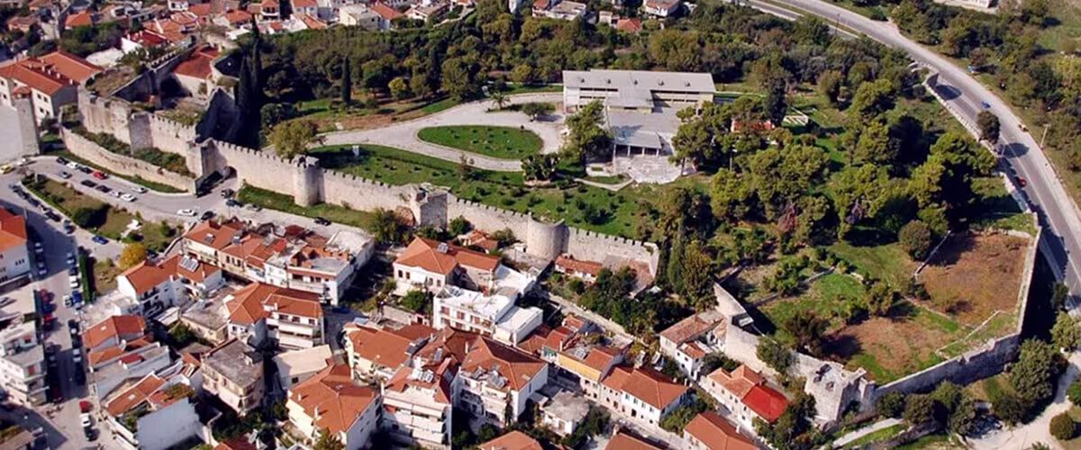
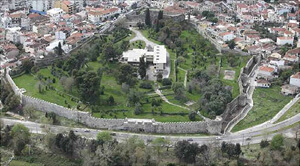
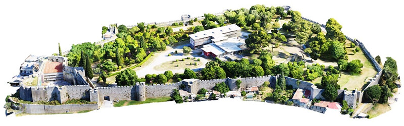
The Castle of Arta is one of the best-preserved Byzantine fortresses in Greece — the stronghold from which the rulers of the Despotate of Epirus governed their realm for more than two centuries. It rises on a low hill on the northeastern edge of the modern city, beside the river Arachthos, dominating the surrounding landscape. It remains one of Arta’s most enduring landmarks, bearing witness to the city’s continuous habitation from antiquity to the modern era.
Built on the site of the acropolis of ancient Ambracia, the castle incorporates substantial sections of the ancient fortifications, especially along its northern and eastern sides, where the river provided a natural defense. This strategic location reflects a continuity of settlement and an awareness of the site’s defensive advantages since classical times. The first Byzantine fortress was likely established in the mid-Byzantine period, then expanded and reinforced under Michael II Komnenos Doukas (r. c. 1230–1266/68). These works transformed it into one of the strongest fortresses of the Despotate of Epirus and the principal residence of its rulers, symbolizing both their authority and the prominence of Arta as their capital.
Over the centuries, the castle underwent several phases of repair and alteration, especially during Ottoman rule. By the 19th and 20th centuries, much of its original internal fabric had been transformed: the mosques, houses, and churches that once stood within its walls were gradually destroyed, while new constructions — including the Xenia Hotel, built in the 1960s — reshaped the interior. Despite these changes, the Castle of Arta still conveys the image of a medieval stronghold that once stood at the heart of the Despotate, and remains one of the main landmarks of the city and of its Byzantine past.
Castle of Arta — in brief
Location:
Arta, Epirus, Greece — northeastern edge of the city, on the hill of ancient Ambracia, beside the river Arachthos
Origins:
acropolis of ancient Ambracia
(walls of the 6th–4th c. BCE)
Main Byzantine builder:
Michael II Komnenos Doukas (r. c. 1230–1266/68)
Role:
principal fortress and residence of the rulers of the Despotate of Epirus
Towers:
19, plus one (Π20) reinforcing the inner citadel
Area:
roughly 40 acres (about 16 ha)
Building phases:
mid-Byzantine · late Byzantine · Ottoman · modern
Later history:
Ottoman rule until 1881;
Xenia Hotel built inside in the 1960s
Today:
standing landmark, excavated 2011–2015
Ancient fortifications of Ambrakia
Opinions of scholars as to when the fortifications of Ambrakia were first built vary. It is probable that the ancient city had a simple enclosure of simple design and construction in the 6th century BCE, while in the middle of the 4th century BCE, a new fortification of monumental construction was built. Its course is known for about its entire perimeter within modern Arta. It was reinforced at various points with rectangular and semi-circular towers.
The walls served a double purpose throughout their history. On one side, they were a defensive structure providing shelter in case of attack; on the other, they protected the city from the rushing waters and floods of the nearby river Arachthos. The walls, especially on the northern side of the city, were mainly intended to prevent its destructive attacks and for this reason, parts of them were not razed to the ground and instead spared in 167 BCE when the Romans destroyed the wall of the continental cities of Epirus.
These surviving parts on the northeastern side were later reused by the Byzantines in the 13th century. They show an imposing and elaborate construction.
The defensive character of the site and the strength of the fortifications proved their value already in ancient times, preventing Philip V of Macedonia’s attack in 219 BCE or resisting, though unsuccessfully – the famous siege of the Romans in 189 BCE. The decline of the city during the Roman time, especially after the foundation of Nicopolis in 29 BCE, where the largest part of the population relocated, explains why it fell into obscurity until the Late Byzantine period, even though the site remained sparsely occupied in the early and Middle Byzantine periods. The foundation of a tower, excavated in the castle, dates back to this last period and shows that the position was already holding defensive fortifications.
The castle of Arta, stronghold of the despotate of Epirus
The foundation of the Despotate of Epirus in 1205 brought Arta back to the forefront as one of the most important cities of the new state.
Michael I Komnenos Doukas probably began investing in fortifying his power base, but most of the Byzantine fortification work took place under the rule of Michael II Komnenos Doukas (1230–1266/68), who established Arta as his capital. It was likely during his reign that the castle acquired the general form it still retains today. The city became the strongest and largest administrative, political, and military center of Epirus, as well as the seat of the ruler.
This prominence made it a target for enemy attacks, and the castle proved its strength by withstanding numerous sieges and assaults. In 1304, for instance, the Chronicle of Morea reports that the invading troops of Charles II of Naples, attempting to seize the Despotate from the young Despot Thomas and his mother Anna, found the city of Arta deserted. The castle, however, was fully prepared for defense. Its strength — the castle is described as “noble” and “si fors” (so strong) — repelled their assault, and the siege, proving ineffective, discouraged further attempts. The invaders turned instead toward the castle of Rogoi – another key fortification in the region – but they were defeated there by Thomas’s forces. In a last attempt, they tried again to attack the castle of Arta, but running low on supply without having managed to capture any stronghold, they finally withdrew from Epirus. Later, the troops of Emperor Andronikos II Palaiologos (1282 to 1328) also failed to capture the castle.
However the castle’s strength was increasingly tested after the middle of the 13th and 14th centuries, as attacks from the neighbouring powers intensified. Byzantine rulers, as well as armies of the Franks, Serbs, and Albanians attacked the city and its castle, which suffered extensive destruction and fire.
The castle under the Orsini, Byzantines, Serbs and Albanians (1318 – 1416)
In the period between 1318 and 1336, Arta and the Despotate came under the control of the Orsini family, a prominent Italian lineage active in Epirus at the time. John I Orsini was the first to show some pretenses over the Despotate of Epirus, but it was his son Nicholas Orsini, already Count Palatine of Cephalonia and Zante, who made this vision come true. He became Despot in 1318 after murdering his uncle Thomas Komnenos Doukas, however at that time his family had already become largely Hellenised and orthodox, and they had reneged their loyalty to the Kingdom of Naples. The castle retained its prominence under the rule of the Orsini.
In 1336, after Nicholas’ son, John II, was allegedly poisoned by his wife Anna Palaiologina, Byzantine Emperor Andronikos III Palaiologos invaded Epirus, seized Arta and Anna as hostage. However her son Nicephorus escaped to the court of Catherine II of Valois, in Taranto. While she stirred some unrest in Epirus, and Alexios Kaballarios rebelled in late 1338 against the Emperor, seized Arta and the castle of Rogoi.
Nicephorus also moved into Epirus, hoping to recover his domain. However Andronikos III and John Kantakouzenos subdued the rebellion of Kaballarios and besieged Nicephorus in Thomokastron. When the garrison surrendered, Nicephorus was married to John Kantakouzenos’ daughter, and spent more than a decade in the Byzantine realm.
In between, the Serbs had taken control of Epirus and Arta in the late 1340s. In 1355, taking advantage of the Byzantine civil war and the anarchy following the death of Stefan Uroš IV Dušan of Serbia, Nicephorus returned to Greece to rally his supporters. He took over Thessaly in 1356 and advanced on Epirus, chasing out Dušan’s brother Simeon Uroš (who was also his brother-in-law) from Arta and the other cities of the region.
However, the countryside had been overrun by the Albanian clans, and it proved impossible to control them. To avert Serbian reaction, Nicephorus set aside his wife Maria Kantakouzene and prepared to marry Theodora of Bulgaria, the sister of Dušan’s widow Helena, who governed Serbia for her son. However, the popularity of Maria among the Epirote nobility forced Nicephorus to abandon this plan and recall her. Soon after, he was killed in 1359 in the Battle of Achelous, in Aetolia, against the Albanians. Albanian clans, dominated by the Spatas family, ruled thereafter Epirus and Arta for a few decades. Their domination didn’t leave many traces in the castle, while in Arta, only a badly damaged fresco in the Panagia Paregoritissa witnesses their rule.
The castle of Arta under the Tocco dynasty (1416-1449)
At the beginning of the 15th century, Carlo I Tocco, Count Palatine of Cephalonia and Zante, aimed at extending his territories in mainland Greece and reestablishing the Despotate of Epirus. Taking advantage of internal strife of the Albanians, he took control of Ioannina in 1411 and besieged the castle of Arta repeatedly.
The Chronicle of the Tocco describes the hard battles that were fought against the Albanians. Finally, the Albanians, unable to maintain their position after a long siege, retreated in 1416 and handed over the castle to Carlo.
And from there the ruler’s officials departed; they raised the banner to the upper tower, took control of the towers, and seized the keys. And from that time the Despot himself also ascended; he took up the banner, regained the territory, and the castle.
Chronicle of the Tocco
The Tocco family maintained control of Epirus and Arta until the Ottoman conquest. Carlo I was succeeded by his nephew, Carlo II, in 1429. The last mention of the castle appears in a document dated March 6, 1441, during his rule.
Following Carlo II’s death on March 29, 1449, the Ottomans took advantage of the succession to advance unopposed into Epirus. Fearing an attack, a group of local inhabitants met the invaders and declared submission to the sultan, negotiating certain privileges. This allowed the Ottomans to seize Arta and the castle without armed resistance, ultimately incorporating the region into their empire.
The castle in Ottoman and modern times
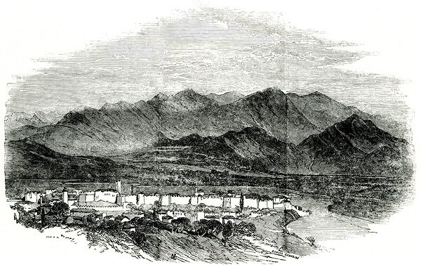
The Ottoman traveler Evliya Çelebi visited Arta in 1670 and described the castle as a cyclopean stone structure with four sides, counting 18 towers. He estimated its perimeter at two thousand and sixty steps. He also mentioned the presence of a royal seraglio inside the castle, where the guard resided. During the modern period, the castle underwent substantial changes. The Byzantine fortifications were modified and strengthened, and a mosque was erected. Further repairs and modernizations were carried out under the rule of Ali Pasha of Ioannina (1796–1820) to adapt it to contemporary siege tactics and the firearms of the early 19th century. Later in that century, the castle primarily served as a prison. The Ottomans maintained control until 1881.
Scientific study of the castle began with the architect and restorer Anastasios Orlandos in 1936. He documented the monument’s different building phases by identifying distinct masonry types. He also studied the buildings within the castle. Orlandos concluded that the monument mostly dated to the Late Byzantine period and attributed its construction to Michael II Doukas. Between 1959 and 1961, the architect Dionysios Zivas carried out restoration and consolidation work on the walls. These efforts were part of the construction of the Xenia Hotel and the general promotion of the castle, and Zivas further studied the site.
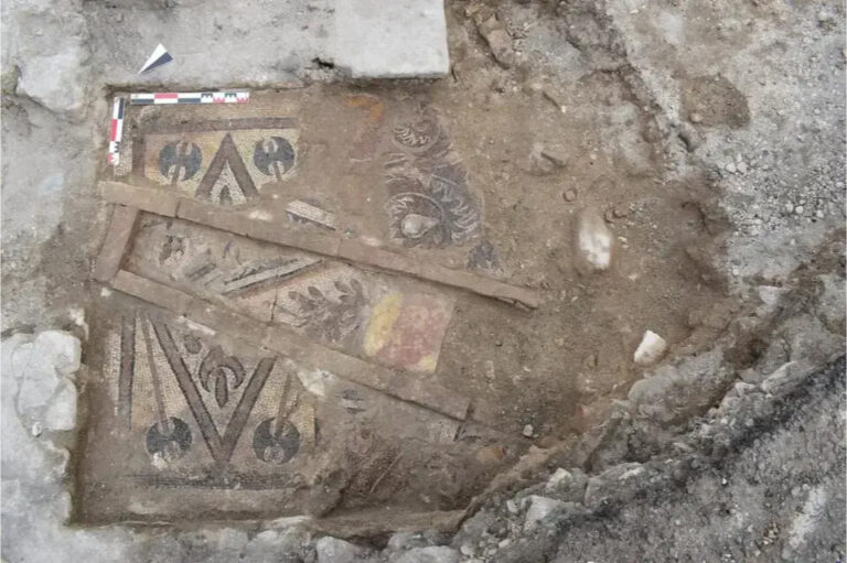
More archaeological data emerged between 2011 and 2015, when extensive excavations were conducted. Researchers discovered that several Byzantine towers, mainly on the northwest side, were based on the remains of ancient fortification towers. A tower foundation from the middle Byzantine period was uncovered beneath the corridor of the inner citadel, indicating that the site had been fortified before the Despotate of Epirus.
Despite these studies, the 20th century brought further modifications. The mosque and some churches were destroyed, and the Xenia Hotel, built in the 1960s in the middle of the compound, damaged Byzantine remains in that area, possibly including those of the Despot’s palace.
Main structures and architectural features of the castle of Arta
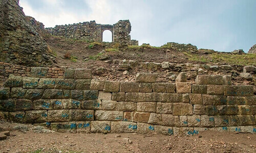
The Castle of Ambracia incorporates fortifications with origins in the 6th–4th centuries BCE, characterized by embankments of small stones, argoliths, and river pebbles, with sophisticated platforms and lever-hole marks indicating advanced construction techniques. During Byzantine times, the Castle underwent at least two major construction phases. The mid-Byzantine phase rises from the ground to about ten meters, with masonry of worked limestone and scattered bricks forming ramparts and perimeter walls. The late Byzantine phase added height and ramparts, largely following the earlier style while incorporating brick-enclosed sections in places. Later repairs in modern times, including cement mortar interventions and modifications to the central gate, have partially altered the original masonry.
Notably, the Castle of Arta occupies a relatively small area—around forty acres—especially when compared to the larger fortresses of Rogoi and Ioannina, despite serving as the capital of the Despotate of Epirus. The interior of the Castle has been significantly altered by modern interventions: houses, mosques, and churches have disappeared, while tree planting and the construction of the Xenia Hotel have changed its original appearance.
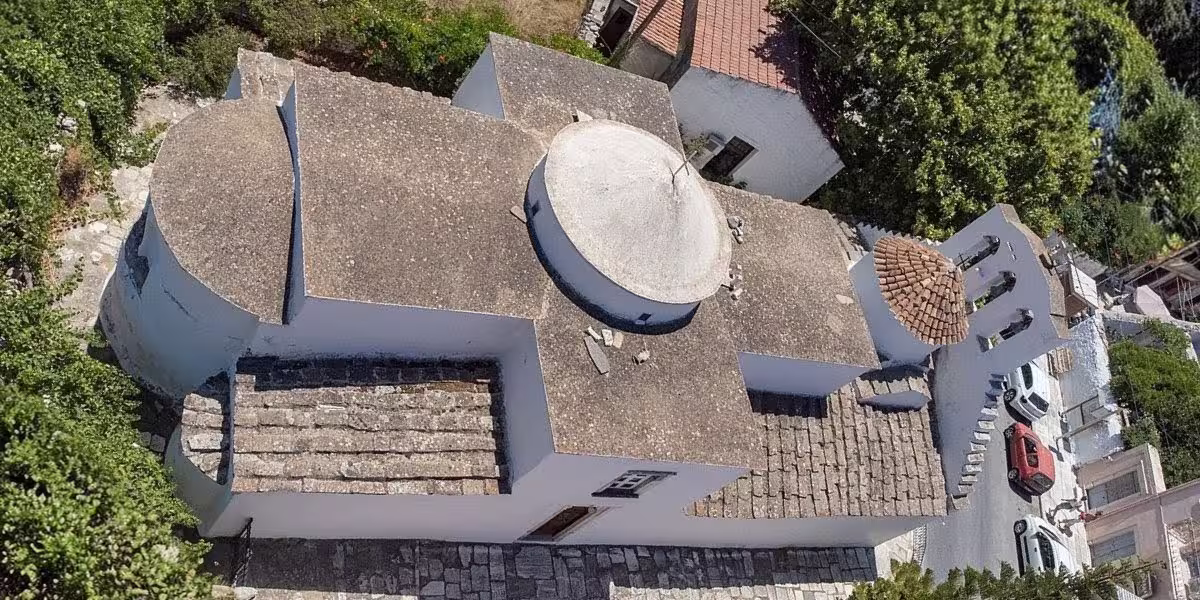
The Acropolis (or inner citadel) of the castle
In the southwest corner of the fortification walls, just beyond the main gate, lies the Inner Acropolis of the Castle. This fortified complex includes a main entrance further protected by the outer fortress wall. Its present form reflects a series of interventions carried out during the Byzantine and Ottoman periods.
The site covers an area of approximately 1,865 square meters. Known as the Acropolis of the Castle, or kastraki (also Kale), it corresponds to the goulas – a term used in medieval sources to denote a tower-fortress.
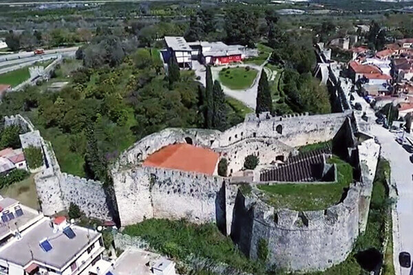
The walls, rising up to 11 meters, demonstrate exceptional strength and craftsmanship. Their imposing structure transformed the Inner Acropolis into a secure stronghold during sieges, designed to serve as the last refuge for the castle’s defenders if the outer fortifications were breached.
Within the enclosure, three buildings remain standing, each modified through the centuries. Their earliest construction phases likely date to the Byzantine period. On the northern side stands the largest building, above whose entrance a marble slab with a carved lion is embedded. The slab may have originated from a Byzantine iconostasis, possibly from a church once located inside the Castle. On the eastern side lies a small basement, believed to have served as a prison; local tradition holds that General Makriyannis (1797–1864) was confined there in 1821. Another smaller structure stands opposite the gate, near a well bearing an engraved coat of arms.
The citadel’s irregular plan reflects the natural terrain and successive building phases. Its fortification features result from continual adaptation to advances in siege warfare and the use of firearms. Consequently, the current configuration of the Inner Acropolis may not correspond to its original purpose. Earlier construction phases might have belonged to architectural complexes with functions beyond purely defensive needs.
Exterior of the inner citadel
The fortifications of the inner citadel form part of the larger defensive system of the Castle of Arta. They occupy the southwest corner between Towers Π19 and Π16 and include a large polygonal bastion from the late Ottoman period. This bastion, with its sloping masonry and decorative stone banding, reflects early 19th-century fortification techniques and may incorporate a Byzantine tower within its core. Its upper platform supported several cannons, while adjacent Byzantine structures, such as Tower Π19 and the inter-tower sections, show arched openings and ramparts adapted for firearms during the Ottoman period.
The entrance to the inner citadel lies beside the castle’s central gate. It consists of an arched passage framed by reused ancient materials and protected by an outer rampart about 25 meters long. This wall formed a narrow corridor for defenders and underwent several construction phases, including the addition of loopholes and elevated ramparts to enhance defense. The citadel’s main gate, built with marble lintels and column fragments, was defended by a machicolation supported on stone brackets.
Inside the citadel, several structures survive. Near the southwest corner stands a courtyard-like area with a well bearing the Tocco family coat of arms, possibly indicating an open peristyle layout. A vaulted building occupies the northwest side, and remains of another, elongated Byzantine structure are preserved beneath the modern theater. A small vaulted basement on the east side, traditionally identified as the prison of General Ioannis Makrygiannis in 1821, links the site to the Greek War of Independence.
Other surviving buildings include a nearly square Ottoman structure opposite the entrance, with vaulted interior and decorative marble relief, and a large trapezoidal building in the north corner combining Byzantine and Ottoman features, including a relief of a lion above its entrance. On the south side, remains of a monumental Byzantine building built with carefully worked stone and decorative brick patterns suggest an official or ceremonial function, though its full layout remains to be confirmed by excavation.
The towers of the castle of Arta
The Castle is reinforced by 19 towers of rectangular, semi-circular, polygonal, or triangular shape, with an additional tower (Π20) reinforcing the inner Acropolis. The towers are among the most distinctive architectural features of the Castle, some built on the foundations of ancient towers that formed part of the fortifications of Ambracia. Their construction reflects multiple historical phases, including the Archaic period, Byzantine period, Ottoman period, and the modern era. As the strongest and most crucial defensive installations, the towers underwent numerous modifications over time to adapt to evolving military needs, particularly the introduction of firearms and cannons. Many towers were elevated to give defenders higher vantage points, reinforced to support light artillery, and fitted with cannon openings on the ramparts. The inner walkway, preserved along the walls, connects all the towers.
Among the towers, some are purely works of the Middle-Byzantine and Late-Byzantine period (Π3, Π9, Π20), some of the same period with Ottoman modifications (Π1, Π2, Π4, Π5, Π8, Π10, Π11, Π14, Π15, Π16, Π18), some may be Byzantine but only works of the Ottoman period are visible (Π6, Π12, Π17, Π19), while others were entirely built in the Ottoman period (Π7, Π13).
Tower Π10
Tower Π10, an important semicircular tower of the Castle, stands about 9 m high with a radius of 5.5 m. It is the only non-embanked tower in the fortress and features walls 1.5 m thick, which narrow to 1 m at the level of the internal beams. The tower originally had a perimeter and a defensive parapet with seven ramparts.
Inside, two main construction phases are evident, likely dating to the Byzantine period. Initially, the tower reached only up to the level of the beams, where a lower perimeter and ramparts, about 1.5 m below the current ones, provided defense. Later, the tower was reinforced with a higher level of defense and new ramparts.
The east and south sides of the tower each have a gate, probably post-Byzantine additions. At the southern gate, two construction phases can be identified. The original doorway was supported by pegs and pillars to protect the threshold. In a later phase, the threshold was raised by about 0.5 m using reused material, including a column and a piece of marble, possibly from an iconostasis. The door was further secured with a beam fitted through opposing holes. The eastern gate was constructed similarly, though it shows only a single phase.
The perimeter wall continues from Tower Π10 to the triangular “false tower” Π11, protected by a parapet of twelve rectangular ramparts. Internally, traces of an older, lower perimeter at about 1 m height are still visible, suggesting that the Byzantine castle was reinforced in at least two phases, with a lower original height. Similar construction phases are observed on the east side of the Castle, along the 24.5 m-long, 8 m-high wall segment between Towers Π10 and Π11.
Tower Π3 and engraved inscription
Tower Π3 is located about 75 m east of the Castle’s main gate. It is semicircular, approximately 5 m in diameter, with walls 1.6 m thick. The structure consists of the main tower body and a defensive parapet. Over time, the tower was partially filled with soil and other materials up to the level of its floor, and two types of masonry are visible on its façades.
An engraved inscription is located roughly in the middle of the tower’s façade and has been studied periodically by scholars. In the first analysis, conducted by Theocharis Tsoutsinos in 1993, the inscription was read as the letters M.A.D.K., interpreted as Michael Angelos Doukas Komnenos, suggesting the ruler who repaired and strengthened the Castle. However, this interpretation was not well-documented and has not gained wide acceptance.
More recent research by Professor Georgios Velenis interprets the inscription as indicating the Byzantine year 6878, corresponding to 1369–70, when Arta was under Albanian rule. The name Ioannis is also visible, though it remains unclear whether it refers to a historical figure. This reading is currently considered the most plausible explanation of the inscription.
Southern part of the castle
The south side of the Castle is accessible from the modern city of Arta via an uphill road that leads to the main Gate. This side extends for 237 m and includes the central Gate along with six towers (Π1–Π6) of varied typology: two circular, two triangular, one square, and one pseudo-tower. Intervals between towers range from 20 to 25 m. Both externally and internally, the south side preserves all four construction phases: mid-Byzantine, late Byzantine, Ottoman, and modern. Unlike other sides of the Castle, no traces of ancient fortifications survive here.
The Main Gate
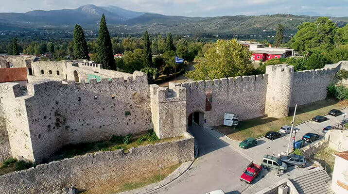
Aerial view of the main gate 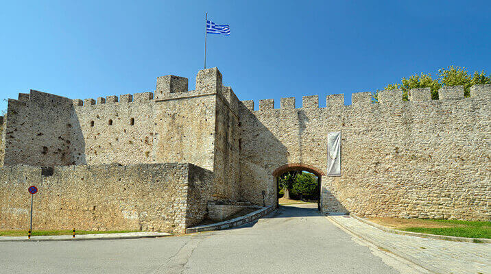
Front view of the main gate 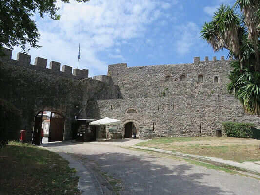
View of the main gate from the inside
The Main Gate of the castle is located between Towers Π19 and Π1. It provides access to the main entrance of the site and leads into a courtyard. The gate measures approximately 4 meters wide and 4.2 meters high, topped with a U-shaped plinth. Its current appearance results from modern modifications. During the 1960s, several interventions were carried out at the Main Gate, likely guided by the surviving traces of its original form.
Indeed, in Byzantine times, the Main Gate was larger and may have featured a different type of crowning. The traces supporting this view are visible on the exterior side, about 1 meter higher than the current arch. The gate is flanked on the left by the Byzantine rectangular Tower Π19, which was altered during the late Ottoman period, and on the right by the semi-circular Tower Π1.
Eastern part of the castle
The east side runs parallel to the city’s Ring Road, stretching 199.2 m with a maximum height of 11.5 m, defined by Tower Π6 to the southeast and Tower Π8 to the northeast. Its length and the hill’s relief create two minor fractures following the terrain. The river Arachthos naturally protected this side, so it required few defensive structures. Only the two end towers and the Ottoman Bastion Π7, used as a cannon battery, mark its fortifications. The outer rampart, partly preserved, likely served also as a retaining wall against river floods.
The strategic significance of this area predates the Byzantine Castle. Ancient Ambracia’s inhabitants built their city walls here, reusing the site’s natural advantages. Portions of the ancient fortifications remain integrated into the Byzantine east and north walls. In the middle of the east wall, oversized limestone blocks—some measuring 5.35 m in length and 2 m in height—are preserved. These were quarried directly from the hill’s bedrock. Carvings on the natural rock, arranged in bands, likely functioned as steps. During the Byzantine period, builders reused materials from the ancient fortifications to save time and effort.
The seat of the Despotes of Epirus
The Castle of Arta, capital of the Despotate of Epirus, was likely the seat of power and residence of its rulers, combining residential, administrative, and ceremonial functions typical of a Byzantine palace complex. In 1960, the renowned Greek architect Dionysios Zivas designed and constructed the Xenia Hotel within the castle grounds, as part of a nationwide initiative to promote cultural tourism through modernist architecture. The hotel partially encroached upon the site of a large Byzantine building. Architectural evidence indicates that this structure was monumental and carefully constructed, with finely cut ashlar masonry, elaborate façades featuring pilaster strips, arched openings, and decorative brickwork. Its scale and sophistication support its identification as the palatium of the Komnenos-Doukas dynasty, the ruling family of Epirus. This interpretation is corroborated by historical testimony, notably that of the 17th-century Ottoman traveler Evliya Çelebi, who described a multi-storey “sarayi” (palace) within the castle, likely still standing in his time.
The underground building
Along the path on the eastern side of the Castle near Tower Π4, the so-called “underground building” was uncovered during excavations conducted between 2011 and 2014. This substructure is visible from only one façade and is built along a north-south axis using medium-sized, carefully dressed stones. Its dimensions are 5.5 × 2.5 m. Access to the interior is provided by three ramps, and the arched entrance is protected by a low masonry wall. Based on its architectural features, the building is believed to have functioned as a storage space.
Northern Part of the castle
The northern side of the Castle runs almost parallel to the city’s Ring Road, extending across a section that once formed part of the wider bed of the river Arachthos. The wall follows a zigzag course, divided into nearly straight segments adapted to the terrain, alternating between rocky outcrops and clay soil. It stretches for about 170 m, with a maximum height of 9.5 m, between the northernmost semicircular Tower Π8 and the northeastern rectangular Tower Π12. Its direction runs roughly from northeast to southwest and includes three semicircular towers, a triangular pseudo-tower, and a rectangular one.
Access to the Castle from this side was provided through Tower Π10, which housed the North Gate. The gate opens to the east, about one meter from the wall, with a width of 1.5 m and a height of 2.25 m, ending in a horseshoe arch. A second, later entrance was added on the west side of the tower, measuring 1.4 m in width and 2.05 m in height. Between Towers Π8 and Π10, the Byzantine wall rests directly on the remains of the ancient fortifications of Ambracia. This preserved section of the ancient wall, still visible today, ranges in height from 1.5 to 3 m and extends for approximately 92 m.
North Gate
On the northern side of the Castle lies a smaller entrance, the North Gate, located within Tower Π10 of the walls. Internally, the gate opens to the southeast side of the tower, while its exit leads to the northeast and connects with the inner corridor of the main fortress wall. About twenty meters to the north, a small gate (pylida) on the bulwark provides access outside the fortifications. The current form of the gate and its hosting tower results from post-Byzantine interventions. Notably, spolia – materials from earlier constructions, such as a section of a marble slab and a column shaft – were incorporated into the gate’s construction. Its placement and design may also have facilitated communication with the River Arachthos, which is believed to have been navigable until the Middle Ages.
Western part of the castle
The western side of the Castle stands at a height varying between 8.3 and 11 m. Unlike the northern and eastern sides, it preserves no visible remains of ancient fortifications or reused ancient stones in its masonry. This is because its alignment differs entirely from that of the ancient wall, adapting instead to the irregular contours of the hillside. Extending for about 178 m, the wall runs between the three-sided Tower Π16 and the polygonal Bastion Π17, continuing thereafter to the southeast. Five interconnected defensive sections culminate in rectangular ramparts.
The masonry on this side consists primarily of small stones laid in a roughly horizontal system, with interspersed tiles and bricks. As in the northern section, traces of an earlier defensive level are visible about 1.5–2 m below the current ramparts. These features indicate two main Byzantine construction phases: the first dating to the Middle Byzantine period, and the second, likely, to the era of the Despotate of Epirus. A third phase of repairs and reinforcements occurred during the Ottoman period, reflecting ongoing efforts to maintain the Castle’s defensive strength through successive centuries.
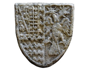
The well with coat of arms of the Tocco family in the Inner Citadel
Detail of the coat of arms of the Tocco dynasty. On the right, the double eagle represents Epirus. 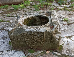
Within the castle of Arta stands a well bearing the coat of arms of the Tocco family.
In the acropolis of the Castle of Arta, a carved coat of arms appears on a well. The coat of arms is an elaborate composition reflecting both Byzantine and Latin influences. Earlier scholars, including Anastasios Orlandos, attributed it to the Orsini family. Recent research by Brendan Osswald of the French School at Athens, however, reassigns it to the Tocco family, rulers of Arta between 1416 and 1449. Osswald demonstrates that the emblem combines the Tocco and Taranto insignia with the Byzantine double-headed eagle, reflecting both Western and Byzantine heraldic traditions. Its right half bears the double-headed eagle, symbol of the Byzantine Empire and the Palaiologos dynasty, while the left half is divided into two parts: the lower section shows the Tocco family emblem, and the upper displays the arms of Robert of Taranto, acknowledging his dual role as Prince of Achaia and heir to the Latin throne of Constantinople. This emblem is a rare and significant testimony to the feudal organization of late medieval Greece and to the brief but notable Italian presence in Epirus under the Tocco dynasty.
Lost monuments in the castle of Arta
At the end of the 19th century, according to Metropolitan Serapheim Xenopoulos of Arta, two churches stood within the Castle – one in the inner citadel and another inside a later, Ottoman-period house. Both were demolished during the Turkish rule.
The same source mentions the presence of a mosque within the Castle. The Mosque of Sultan Mehmet, believed to have been built in 1455 by Faik Pasha, is generally associated with this site, though its exact date of construction remains uncertain. Anastasios Orlandos also refers to the mosque, and 19th-century engravings as well as early 20th-century photographs confirm its existence. It stood on the northern side of the Castle, was of considerable size, and had a tall minaret that rose well above the fortifications. The precise date of demolition remains uncertain.
While the castle’s own churches have vanished, Arta still preserves some of the finest Byzantine churches in Greece — among them the Panagia Paregoritissa, the Church of Saint Theodora, or the monastery of Kato Panagia, and the monastery of Panagia Vlacherna — legacies of the same despots who held this fortress.
FAQ
Who built the Castle of Arta?
The first Byzantine fortress was raised in the mid-Byzantine period on the acropolis of ancient Ambracia, but the castle owes its present form to Michael II Komnenos Doukas (r. c. 1230–1266/68), ruler of the Despotate of Epirus, who expanded and reinforced it as his principal stronghold.
When was the Castle of Arta built?
The site has been fortified since antiquity (the walls of Ambracia date to the 6th–4th centuries BCE). The medieval castle took shape mainly in the 13th century under the Despotate of Epirus, and was repeatedly modified during the Ottoman period and the 19th–20th centuries.
Can you visit the Castle of Arta?
Yes. The castle is one of Arta’s main landmarks and an open archaeological site; its walls and towers can be walked, and the grounds include a modern open-air theater.
Why is there a hotel inside the Castle of Arta?
The Xenia Hotel was built within the walls in the 1960s by the architect Dionysios Zivas, as part of a national program promoting cultural tourism through modernist architecture. It was built over a large Byzantine structure, possibly the palace of the Komnenos-Doukas rulers.
How many towers does the Castle of Arta have?
Nineteen towers of varied shape (rectangular, semicircular, polygonal, triangular), plus one additional tower (Π20) reinforcing the inner citadel, built across several phases from the ancient to the Ottoman period.
Whose coat of arms is carved on the well in the citadel?
Recent research by Brendan Osswald attributes it to the Tocco family, who ruled Arta from 1416 to 1449; earlier scholars, including Orlandos, had assigned it to the Orsini.
Sources & further reading
Online
- Castle of Arta — Hellenic Ministry of Culture / Odysseus (Ephorate of Antiquities of Arta)
- Castle of Arta — Kastra.eu (Castles of Greece)
- Castle of Arta — Wikipedia
- Castle of Arta — Municipality of Arta / DiscoverArta
- 3D model of the Castle of Arta — Kic Laboratory on Sketchfab
Scholarship & primary sources
- Chronicle of the Tocco and Chronicle of Morea (medieval narrative sources).
- Evliya Çelebi, Seyahatnâme (Book of Travels), vol. VIII — his account of Arta in 1670. Modern critical edition: R. Dankoff et al. (eds.), Evliyâ Çelebi Seyahatnâmesi, vol. 8, Istanbul, 2003.
- Serapheim Xenopoulos, Metropolitan of Arta, Historical Essay on Arta and Preveza (Δοκίμιον ἱστορικῆς τινος περιλήψεως… πόλεως Ἄρτης καὶ… Πρεβέζης), Athens, 1884 (repr. Arta, 2003). AUTh catalogue record.
- Anastasios K. Orlandos, Archive of the Byzantine Monuments of Greece (Ἀρχεῖον τῶν Βυζαντινῶν Μνημείων τῆς Ἑλλάδος), vol. 2, Athens, 1936.
- Brendan Osswald (French School at Athens), “Les armoiries des Tocco de Céphalonie dans la citadelle intérieure de la forteresse d’Arta,” Bulletin de correspondance hellénique 142.2 (2018), pp. 803–844. Open access: OpenEdition · HAL.
- Studies by D. Zivas and G. Velenis.